
GaIA: Transforming spatial data into reliable decisions
GAIA is an AI analysis engine designed to transform massive and heterogeneous multi-source data into reliable, explainable and directly usable information, dedicated to reactive and predictive decision support.
Making spatial data reliable, structured and used for decision-making.

GaIA AI-powered GEOINT analysis engine
Technology Brick
Universal technology brick, independent of sources and purposes
Exploitation and enrichment
Reliability and traceability of data and processes
Uncertainty management
Reducing uncertainty through mathematical analysis and decision trees
OODA loop acceleration
Accelerate the OODA loop (Observe - Orient - Decide - Act) for decision-making
Reliability and traceability
Facilitate data exploitation and enrichment
Interoperability
Ensure interoperability with existing systems
Services already operational in 3 priority verticals
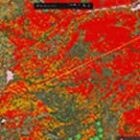
Climate risk management
- Forest fires
- Flooding
- Water resources management
Territorial security
- Gold panning
- Border control
- Field analysis (OCOKA vs activity) Practicability - trafficability
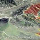
SURMAR
- IUU fishing
- Illicit trafficking
- Strategic infrastructures
- Maritime route safety
A capability-based approach to meet operational needs
LOCATION MAP
Knowledge and understanding
ADVANCED ALERT SYSTEM
Prevention and Planning
FAST RESPONSE
Fast Action